The ridge that gave us a sunny, mid-70s Thursday is still parked offshore, and Friday it deals us one last warm card — sunshine and highs in the upper 70s to low 80s before a cold front even arrives. The front drops in Friday afternoon, but its cold push waits until evening, so the warmth gets the full day and the cooldown only starts after dark. Behind it, the weekend resets to seasonable — highs in the 60s, a dry Halloween evening in the 50s to near 60 for trick-or-treaters, and still no rain to dent the drought.
KEY HIGHLIGHTS
🌡️ One more warm day Friday: Sunshine and dry west-northwest flow lift highs to the upper 70s to low 80s (about 79–81°) in the Piedmont and metro, mid to upper 70s on the Northern Neck and Lower Eastern Shore. The front arrives Friday afternoon, but the cold air lags until evening.
🎃 Halloween stays dry: Saturday highs in the 60s regionwide, increasing clouds Saturday evening, and trick-or-treat temperatures mainly in the 50s to near 60. No rain, no watches, warnings, or advisories in effect for Virginia.
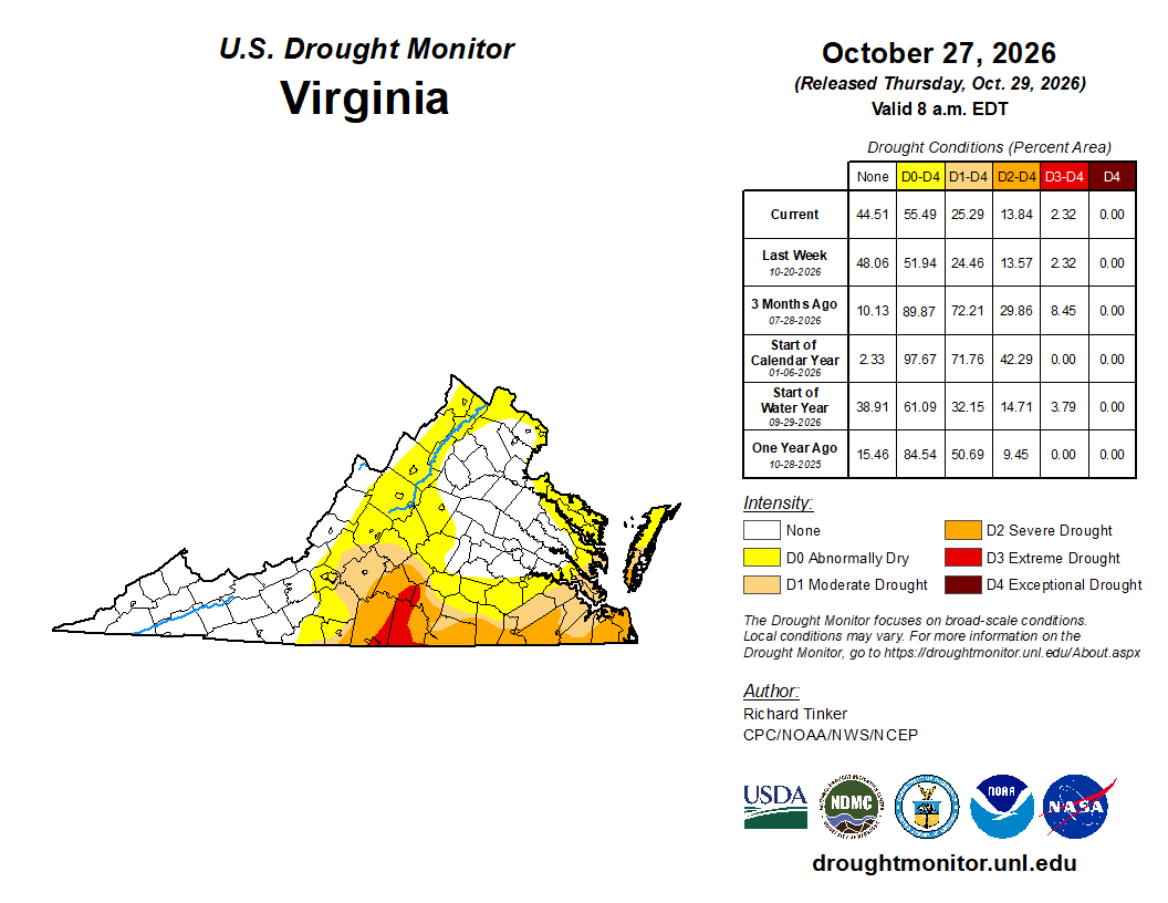
🏜️ Dry pattern deepens: Rain chances for Sunday night into Monday have trended down, and Thursday's Drought Monitor shows dryness expanding — 55.5% of Virginia now at least abnormally dry and 25.3% in drought. Tropics are quiet: NHC expects no formation in the next 7 days.
What weather question should we answer next?
SPECIAL FOCUS: The Front That Arrives in Two Pieces
A 1028 mb high sits offshore of the Northeast coast, ridging back across the Mid-Atlantic, while low pressure over southern Quebec drags a cold front toward us. Friday, that front crosses in two pieces: the wind shift arrives in the afternoon, but the cold air behind it waits until evening. Sunshine and dry west-northwest flow send highs to the upper 70s and low 80s, with dewpoints falling into the upper 40s and low 50s and afternoon humidity down to 35–40%. Translated into plain English: Friday is warm because the front shows up without its cold air — the chill checks in after dark, and a 1032 mb high from the northwest keeps the weekend dry and in the 60s.
What could change this: If the front's cold push arrives hours early Friday, the near-80 highs trim back to the mid 70s and the evening cooldown starts before dinner.
DETAILED FORECAST
Friday (Oct 30): Patchy fog and low stratus possible around sunrise mainly across southeast Virginia and northeast North Carolina, eroding by mid-morning; otherwise sunny and dry. High upper 70s to low 80s Piedmont/metro, mid to upper 70s Northern Neck and Lower Eastern Shore, light W-NW winds. Low Friday night upper 40s inland, low 50s at the coast as cooler air arrives. The warm finale — spend it outside.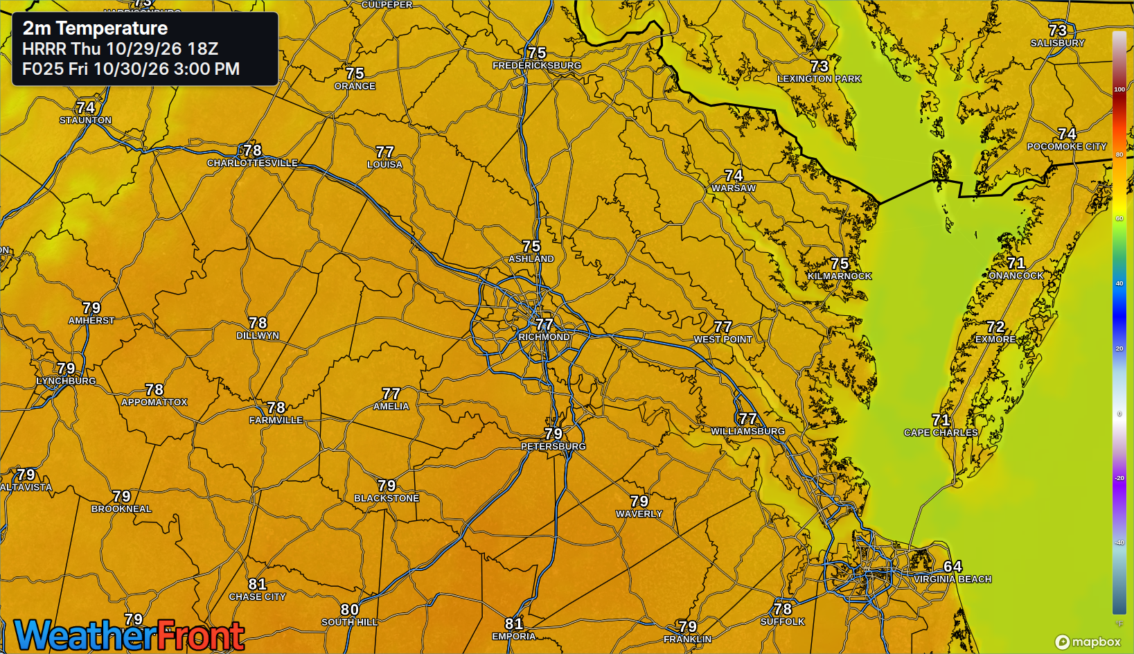
Saturday (Oct 31): Seasonable and dry behind the front, highs in the low to mid 60s Piedmont/metro and mid 60s Northern Neck and Lower Eastern Shore, with a northerly breeze early, easing later. Increasing clouds Saturday evening; trick-or-treat temperatures mainly in the 50s to near 60. Low upper 40s inland, near 50 at the coast. A dry Halloween — jackets over costumes by dark.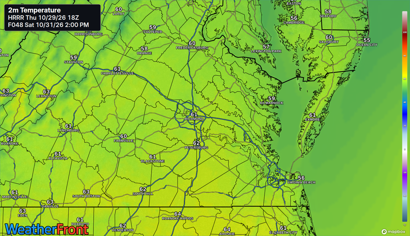
Sunday (Nov 1): Dry and seasonable, morning clouds giving way to sun, high mid-60s (about 64–67°) Piedmont/metro and mid-60s Northern Neck and Lower Eastern Shore, light winds. Clocks go back at 2 AM, so sunset lands near 5:11 PM. Low mid-40s inland, upper 40s at the coast. An extra hour, an earlier sunset.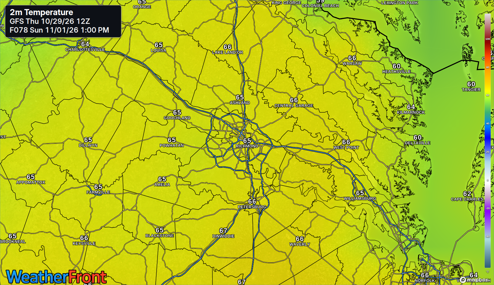
AT A GLANCE
Fri: Sunny, warm — 80°
Sat: Dry, seasonable — 64°
Sun: Clouds to sun, dry — 66°
Next rain chance: Latter half of next week — the early-week chance faded
SPECIALIZED CALLOUTS
🌱 Gardening & Soil Brief: No rain in this window and Friday afternoon humidity drops to 35–40%, so soil keeps drying — deep-water Friday while it is warm. No frost threat (lows mid to upper 40s), covers stay off; drought warnings now cover Goochland, Powhatan, and Amelia on the metro's western fringe, and Richmond's late peak color is expected around Nov 2 and after.
🚗 Commute & Outdoor Rating: 9/10. Friday morning patchy fog is mainly a southeast Virginia / northeast North Carolina risk, not a metro washout, and the front's evening cooldown is the only real change. Saturday and Sunday are dry, light-wind outdoor days.
🏠 Home & Energy Brief: Friday needs neither heat nor air conditioning for most homes — open windows and bank the near-80 warmth before the front. The weekend's 60s and 40s lows bring light, seasonal heating demand only.
🚴 Two-Wheel & Runner's Outlook: Friday is the pick — dry, warm, and low humidity, with light west-northwest winds. Saturday runs cooler in the 60s behind the front, and Sunday's clock change buys an extra hour of morning light for early miles.
COMMUNITY ENGAGEMENT
📩 Reader Mailbag is open — send us your weather question: What have you always wanted to ask? Pick a lane — FROST, FOG, DROUGHT, or STORMS — add your neighborhood, and send the full question at https://rvaweather.net/obs and we will answer one in an upcoming issue. Like this if your question has been sitting unasked — the best ones come straight from your backyard.
📩 Share & Subscribe: Send this to someone making Halloween plans — Friday's warmth and Saturday's dry, 50s-to-near-60 evening are the whole costume forecast. Get the brief in your inbox: https://rvaweather.net/newsletter
Thanks for reading the RVA Weather Brief — 100% free, from the RVA Weather Network team. Support our work at https://rvaweather.net/social. Built on the latest NWS Wakefield forecast discussion (3:11 PM EDT Thu Oct 29, 2026), with local context from the RVA Weather Network team. Keep an eye on the sky — and stay safe out there.