
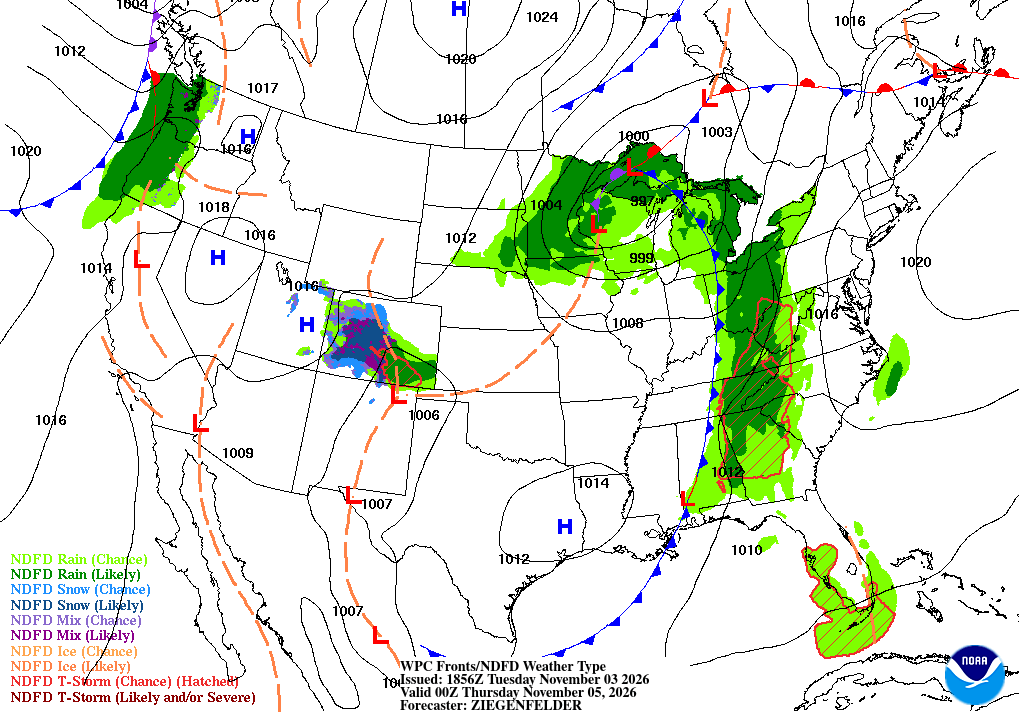
Tuesday gave Richmond one more unseasonably warm, dry afternoon in the 70s, with high pressure still parked offshore and the sky mostly sunny. Wednesday is the warm peak — patchy fog before 8 AM, then mostly sunny and near 78 in the metro, around 80 in the Piedmont, cooler on the Northern Neck and Lower Eastern Shore. Then the story turns: a cold front drags moisture-laden air over us Thursday night into Friday, bringing widespread rain of a half-inch to an inch and a half — the soaking this dry stretch has waited for.
Key Highlights
🌡️ The warm peak comes first: Wednesday runs near 78 in the metro, around 80 in the Piedmont, after patchy fog before 8 AM; Thursday stays warm near 79 under increasing clouds — well above normal, with no watches, warnings, or advisories in effect.
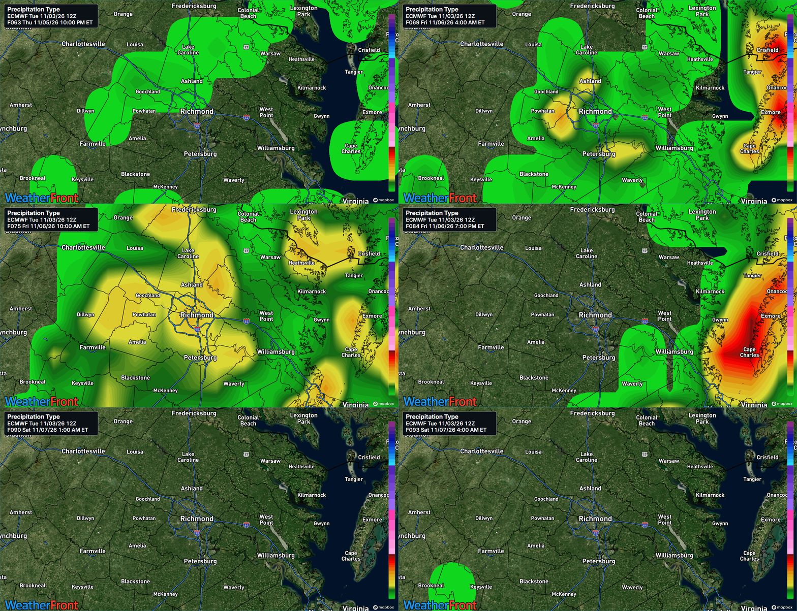
🌧️ Widespread rain Thursday night-Friday: Moderate to locally heavy rain totals 0.50-1.50" along a southwest-to-northeast axis, south-central Virginia to the Maryland Eastern Shore, with locally 2"+ possible across the Northern Neck to the MD Eastern Shore. A few thunderstorms are possible; severe confidence is low.
🌙 Mild nights, and a quiet tropics:
Foggy or clear on your Wednesday drive?
Special Focus: The Moisture Surge That Ends the Dry Run
For days, high pressure has sat offshore like a bouncer, keeping fronts and moisture away while the sun stacked November warmth into the 70s. Wednesday, that bouncer steps aside. A trough and cold front approach from the west Thursday, and ahead of them southerly flow opens a pipeline to unusually rich air — atmospheric moisture (PWATs) surging past 200% of normal for early November. In plain English: the front is the trigger, but the loaded air is the fuel—when a front squeezes air carrying twice the usual moisture, ordinary showers turn into widespread, occasionally heavy soaking, with a few thunderstorms mixed in. Once the front moves offshore Friday evening, drier, pleasant air returns for the weekend.
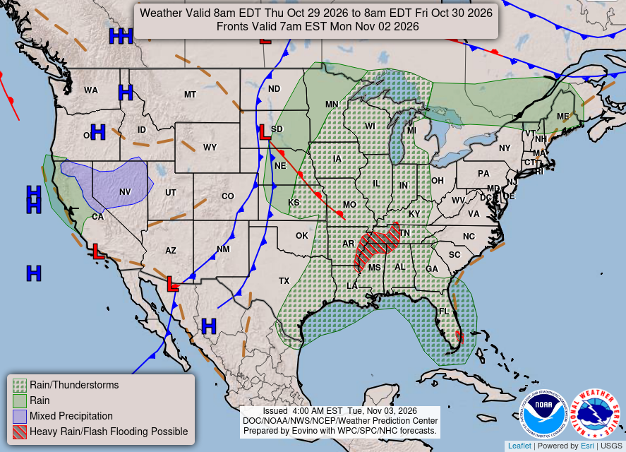
What could change this: If the heaviest axis shifts west, metro totals could push past 1.50 inches; if it stays east, the Northern Neck and Eastern Shore could get 2-inch-plus totals.
Detailed Forecast
Wednesday (Nov 4): Patchy fog before 8 AM, locally dense in calm pockets, then mostly sunny and dry. High near 78 in the metro, around 80 in the Piedmont, mid 70s on the Northern Neck, low to mid 70s on the Lower Eastern Shore; calm winds turn south 5-7 mph. Low around 62 under building clouds. The warm peak — summer's last word before the turn.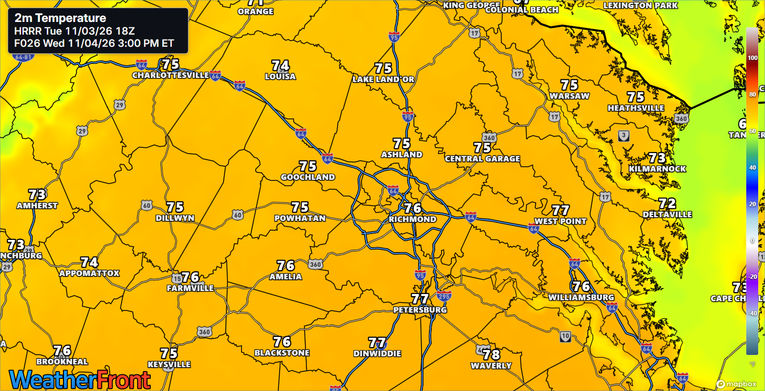
Thursday (Nov 5): Mostly cloudy and still warm, high near 79 in the metro, mid to upper 70s regionwide, cooler at the coast, south winds 6-11 mph gusting to 20. A slight shower chance (20%) favors the Piedmont before 1 PM; widespread rain holds off until after dark. Low around 64, rain likely after 1 AM with a thunderstorm possible (70% chance, 0.25-0.50" overnight in the metro). Clouds gather, warmth lingers — the rain waits for dark.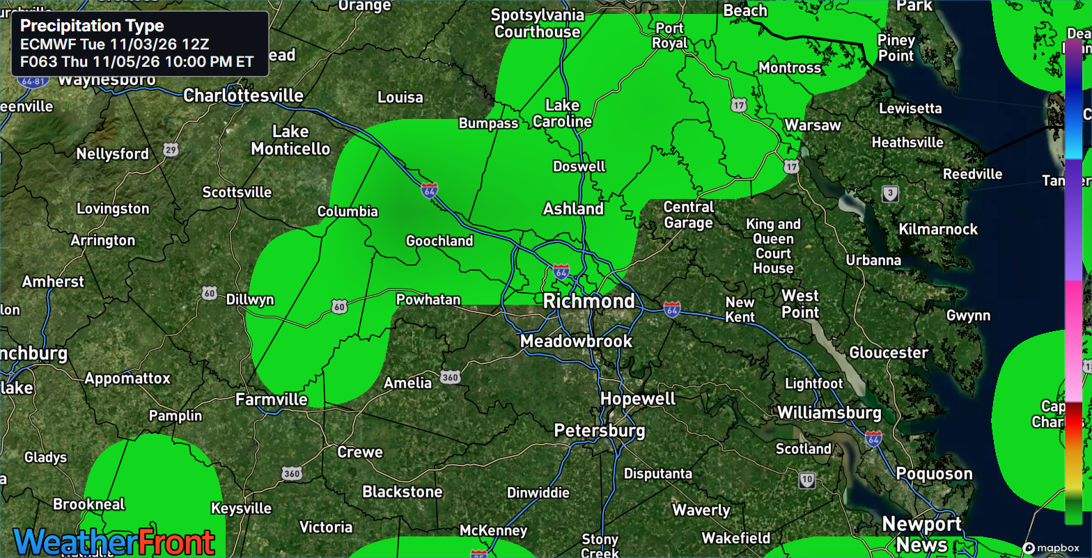
Friday (Nov 6): Showers and possibly a thunderstorm (80% chance in the metro), high near 74. Daytime rain of 0.75-1.00" in the metro brings storm totals to 0.50-1.50", locally 2"+ across the Northern Neck to the Maryland Eastern Shore. Rain diminishes west to east Friday evening; low around 53. The soaking itself — the gauges finally get a workout.
AT A GLANCE
Wed: Fog early, then sunny — 78°
Thu: Mostly cloudy, warm — 79°
Fri: Showers, possible thunder — 74°
Saturday: Front gone — mostly sunny, near 69°, drier weekend
Specialized Callouts
🌱 Gardening & Soil Brief: Hold the hose — Thursday night and Friday deliver 0.50-1.50" of free soaking, exactly what dry soil absorbs best. Use warm, dry Wednesday for cleanup, mulching, and clearing drains so Friday's heavier bursts run off where they should.
🚗 Commute & Outdoor Rating: 7/10. Wednesday is a 9 after the fog lifts and Thursday's daylight stays dry, but budget extra time Wednesday before 8 AM in fog pockets and all day Friday, when heavy bursts could pond water on low spots.
🏠 Home & Energy Brief: Heating demand fades as lows climb from around 50 to the mid 60s Thursday night, and upper-70s afternoons need no air conditioning — open windows Wednesday. Before Friday, clear gutters and check sump pumps; this is the first soaking in weeks.
🚴 Two-Wheel & Runner's Outlook: Wednesday after the fog lifts is the pick — dry, sunny, near 78. Thursday miles are warm but breezy, gusts to 20 mph; Friday is a treadmill day, wet roads and a thunderstorm chance. Saturday dries out for a reset.
Community Engagement
🌫️ Wednesday morning fog check — what did your drive look like? Reply FOGGY, MISTY, or CLEAR + your neighborhood — sky photos welcome — so we can map where the fog settled thickest. Full reports at https://rvaweather.net/obs. Like this if the rain gauge is already out for Friday — those totals are the next map we draw.
📩 Share & Subscribe: Send this to anyone with Friday plans or a dry garden — Thursday night's rain changes both. Get the brief in your inbox: https://rvaweather.net/newsletter
Thanks for reading the RVA Weather Brief — 100% free, from the RVA Weather Network team. Support our work at https://rvaweather.net/social. Built on the latest NWS Wakefield forecast discussion (2:39 PM EST Tue Nov 3, 2026 — the latest available at generation time; no post-3:00 PM discussion had been issued yet), with local context from the RVA Weather Network team. Keep an eye on the sky — and stay safe out there.